Geolocate

Pimlico topographic map

Click on the map to display elevation.

👉 Easily get elevation data in JSON, GeoTIFF and KML formats using Elevation API
Thank you for supporting this site ❤️
Make a donation

About this map

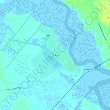
Name: Pimlico topographic map, elevation, terrain.

Location: Pimlico, Berkeley County, South Carolina, United States (33.07739 -79.98036 33.11739 -79.94036)

Average elevation: 7 ft

Minimum elevation: -10 ft

Maximum elevation: 52 ft

South Carolina trails, hiking, mountain biking, running and outdoor activities

Gear up for your next adventure:

🪶Thermal Camp Blanket - Extra warmth for cold nights
🧥Men's Rain Shells - Premium waterproof and breathable jackets for mountain weather
🎒Gear Packing Cubes - Organize your backpack efficiently
🩳Quick‑Dry Hiking Shorts - Comfortable and quick‑dry shorts for summer hiking
📷Action Cameras - Rugged cameras to document your journeys across rugged terrain

As an Amazon Associate, this site earns from qualifying purchases at no extra cost to you.