Geolocate

Caldwell topographic map

Click on the map to display elevation.

About this map

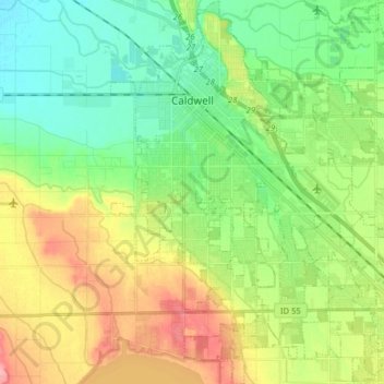
Name: Caldwell topographic map, elevation, terrain.

Location: Caldwell, Canyon County, Idaho, 83605, United States (43.58259 -116.72332 43.69779 -116.58340)

Average elevation: 2,434 ft

Minimum elevation: 2,313 ft

Maximum elevation: 2,635 ft

Canyon County trails, hiking, mountain biking, running and outdoor activities

Other topographic maps

Click on a map to view its topography, its elevation and its terrain.

Fischer Island

United States > Idaho > Canyon County

Average elevation: 2,392 ft

Gear up for your next adventure:

🛏️Cold Weather Sleeping Bag - Warm sleeping bag for cold conditions
🔭Telescopic Hiking Pole - Adjustable pole for hiking stability
🧭Pro Hiking Compasses - High-accuracy liquid-filled compasses for topographic orientation
📚USA Hiking Guide Books - Top trail guides and map books
🛡️Insect Repellent - Protection against bugs during outdoor activities

As an Amazon Associate, this site earns from qualifying purchases at no extra cost to you.