Geolocate

Kosciusko topographic map

Click on the map to display elevation.

About this map

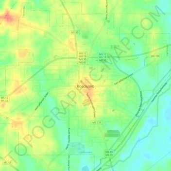
Name: Kosciusko topographic map, elevation, terrain.

Location: Kosciusko, Attala County, Mississippi, 39090, United States (33.03367 -89.61737 33.08199 -89.55845)

Average elevation: 440 ft

Minimum elevation: 364 ft

Maximum elevation: 531 ft

Attala County trails, hiking, mountain biking, running and outdoor activities

Other topographic maps

Click on a map to view its topography, its elevation and its terrain.

Zama

United States > Mississippi > Attala County

Average elevation: 440 ft

Gear up for your next adventure:

🥩Freeze-Dried Meals - Nutritious and lightweight food for remote expeditions
❄️Traction Cleats - Prevent slips on icy trails during winter hikes
📡Handheld GPS Device - Reliable handheld GPS for outdoor navigation
📶Satellite Messenger - Communication device off‑grid
📱Heavy-Duty Phone Cases - Drop-proof and waterproof protection for outdoor navigation

As an Amazon Associate, this site earns from qualifying purchases at no extra cost to you.