
Thank you for supporting this site ❤️
Make a donation
Make a donation
Gear up for your next adventure:
As an Amazon Associate, this site earns from qualifying purchases at no extra cost to you.
Raikot topographic map
Click on the map to display elevation.
Thank you for supporting this site ❤️
Make a donation
Make a donation
Gear up for your next adventure:
As an Amazon Associate, this site earns from qualifying purchases at no extra cost to you.
Raikot
Raikot is located at 30°39′N 75°36′E / 30.65°N 75.6°E / 30.65; 75.6. It has an average elevation of 235 metres (770 feet).
Thank you for supporting this site ❤️
Make a donation
Make a donation
Gear up for your next adventure:
As an Amazon Associate, this site earns from qualifying purchases at no extra cost to you.
About this map
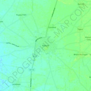
Name: Raikot topographic map, elevation, terrain.
Location: Raikot, Raikot Tahsil, Ludhiana, Punjab, 141109, India (30.60965 75.55931 30.68965 75.63931)
Average elevation: 784 ft
Minimum elevation: 768 ft
Maximum elevation: 794 ft
Thank you for supporting this site ❤️
Make a donation
Make a donation
Gear up for your next adventure:
As an Amazon Associate, this site earns from qualifying purchases at no extra cost to you.