
Bosen topographic map
Interactive map
Click on the map to display elevation.
About this map
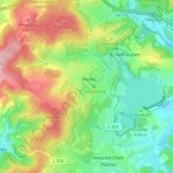
Name: Bosen topographic map, elevation, terrain.
Location: Bosen, Nohfelden, Landkreis St. Wendel, Saarland, Deutschland (49.54925 7.00907 49.58784 7.07890)
Average elevation: 1,483 ft
Minimum elevation: 1,234 ft
Maximum elevation: 1,877 ft
Other topographic maps
Click on a map to view its topography, its elevation and its terrain.
Dollberg
Deutschland > Saarland > Landkreis St. Wendel > Nohfelden
Dollberg, Nohfelden, Landkreis St. Wendel, Saarland, 54422, Deutschland
Average elevation: 1,906 ft
Bliesquelle
Deutschland > Saarland > Landkreis St. Wendel > Nohfelden
Bliesquelle, L134, Gronig, Selbach, Nohfelden, Landkreis St. Wendel, Saarland, 66625, Deutschland
Average elevation: 1,411 ft
Bostalsee
Deutschland > Saarland > Landkreis St. Wendel > Nohfelden
Bostalsee, Gonnesweiler, Nohfelden, Landkreis St. Wendel, Saarland, Deutschland
Average elevation: 1,352 ft
Bosenberg
Deutschland > Saarland > Landkreis St. Wendel > Nohfelden
Bosenberg, Nohfelden, Landkreis St. Wendel, Saarland, 66625, Deutschland
Average elevation: 1,447 ft