
Make a donation
Gear up for your next adventure:
As an Amazon Associate, this site earns from qualifying purchases at no extra cost to you.
Swedesboro topographic map
Click on the map to display elevation.
Make a donation
Gear up for your next adventure:
As an Amazon Associate, this site earns from qualifying purchases at no extra cost to you.
About this map
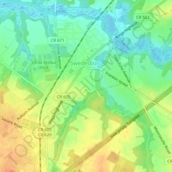
Name: Swedesboro topographic map, elevation, terrain.
Location: Swedesboro, Gloucester County, New Jersey, United States (39.73223 -75.32009 39.75571 -75.30153)
Average elevation: 59 ft
Minimum elevation: -3 ft
Maximum elevation: 125 ft
Gloucester County trails, hiking, mountain biking, running and outdoor activities
Make a donation
Gear up for your next adventure:
As an Amazon Associate, this site earns from qualifying purchases at no extra cost to you.
Other topographic maps
Click on a map to view its topography, its elevation and its terrain.
Woolwich Township
United States > New Jersey > Gloucester County > Woolwich Township
Average elevation: 75 ft
Mount Royal
United States > New Jersey > Gloucester County > East Greenwich Township
Average elevation: 36 ft
Lincoln
United States > New Jersey > Gloucester County > South Harrison Township
Average elevation: 121 ft
Mantua Grove
United States > New Jersey > Gloucester County > West Deptford Township
Average elevation: 36 ft
Make a donation
Gear up for your next adventure:
As an Amazon Associate, this site earns from qualifying purchases at no extra cost to you.
Parkville
United States > New Jersey > Gloucester County > West Deptford Township
Average elevation: 46 ft
Creesville
United States > New Jersey > Gloucester County > Washington Township
Average elevation: 105 ft
North Woodbury
United States > New Jersey > Gloucester County > Deptford Township
Average elevation: 30 ft
Make a donation
Gear up for your next adventure:
As an Amazon Associate, this site earns from qualifying purchases at no extra cost to you.
Creesville
United States > New Jersey > Gloucester County > Washington Township > Creesville
Average elevation: 105 ft
Jericho
United States > New Jersey > Gloucester County > Deptford Township > Deptford > Jericho
Average elevation: 66 ft
Wolfert
United States > New Jersey > Gloucester County > East Greenwich Township
Average elevation: 49 ft
Make a donation
Gear up for your next adventure:
As an Amazon Associate, this site earns from qualifying purchases at no extra cost to you.