Geolocate

Poing topographic map

Click on the map to display elevation.

About this map

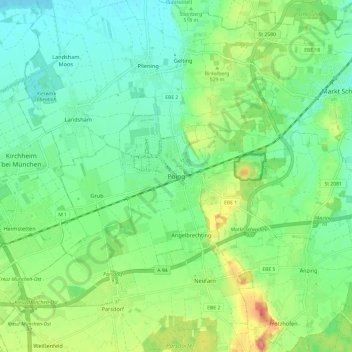
Name: Poing topographic map, elevation, terrain.

Location: Poing, Landkreis Ebersberg, Bavaria, 85586, Germany (48.13205 11.76908 48.21205 11.84908)

Average elevation: 1,699 ft

Minimum elevation: 1,621 ft

Maximum elevation: 1,870 ft

Other topographic maps

Click on a map to view its topography, its elevation and its terrain.

Ebersberg

Germany > Bavaria > Landkreis Ebersberg

Average elevation: 1,837 ft

Hohenlinden

Germany > Bavaria > Landkreis Ebersberg

Average elevation: 1,844 ft

Ebersberg

Germany > Bavaria > Landkreis Ebersberg

Average elevation: 1,837 ft

Steinhöring

Germany > Bavaria > Landkreis Ebersberg

Average elevation: 1,781 ft

Vaterstetten

Germany > Bavaria > Landkreis Ebersberg

Average elevation: 1,759 ft

85614

Germany > Bavaria > Landkreis Ebersberg > Eglhartinger Forst

Average elevation: 1,854 ft

Gear up for your next adventure:

😴Insulated Sleeping Pads - Compact and warm pads for high-elevation camping
🥇GPS Hiking Watch - Multi‑sport GPS watch with navigation and trail tracking
GPS Sports Watch - GPS watch for running, hiking and training
🏕️Tent Footprint - Protect your tent base from wear
🗻Climbing Gear Basics - Essential gear for beginner climbers

As an Amazon Associate, this site earns from qualifying purchases at no extra cost to you.