
Make a donation
Gear up for your next adventure:
As an Amazon Associate, this site earns from qualifying purchases at no extra cost to you.
Area B topographic map
Click on the map to display elevation.
Make a donation
Gear up for your next adventure:
As an Amazon Associate, this site earns from qualifying purchases at no extra cost to you.
About this map
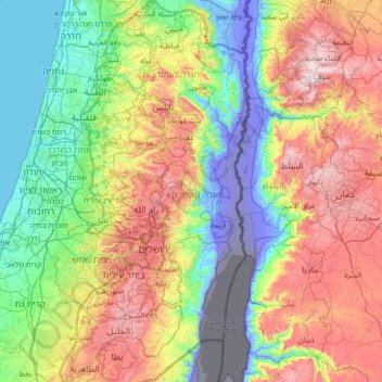
Name: Area B topographic map, elevation, terrain.
Location: Area B, West Bank, Palestinian Territories (31.36631 34.90205 32.54894 35.54036)
Average elevation: 1,070 ft
Minimum elevation: -1,362 ft
Maximum elevation: 4,055 ft
Make a donation
Gear up for your next adventure:
As an Amazon Associate, this site earns from qualifying purchases at no extra cost to you.
Other topographic maps
Click on a map to view its topography, its elevation and its terrain.
Make a donation
Gear up for your next adventure:
As an Amazon Associate, this site earns from qualifying purchases at no extra cost to you.
Khirbat Abu Falah
Palestinian Territories > Area B
Khirbet Abu Falah is situated in a hilly area in the central highlands of the West Bank and has an average elevation of 743 meters above sea level. It is located 15.7 kilometers northeast of Ramallah. The nearest localities are al-Mazraa al-Sharqiyah to the southwest, Turmus Ayya to the north, al-Mughayyir to…
Average elevation: 2,487 ft
Make a donation
Gear up for your next adventure:
As an Amazon Associate, this site earns from qualifying purchases at no extra cost to you.
Make a donation
Gear up for your next adventure:
As an Amazon Associate, this site earns from qualifying purchases at no extra cost to you.
Make a donation
Gear up for your next adventure:
As an Amazon Associate, this site earns from qualifying purchases at no extra cost to you.