Big Sky topographic map
Click on the map to display elevation.
Big Sky
Big Sky is characterized by its dramatic and diverse topography, which forms part of the northern Rocky Mountains. The area features an elevation that ranges from around 5,500 feet in the valleys to more than 11,000 feet at its peaks, including the notable Lone Peak. This mountainous terrain is interspersed with deep canyons, rolling hills, and expansive alpine meadows, which are especially vibrant during the warmer months. The landscape is shaped by glacial activity, resulting in rugged features and stunning vistas that attract outdoor enthusiasts year-round. The proximity to the Gallatin National Forest enhances the region's natural beauty, offering a mix of dense forests and open slopes ideal for skiing in winter and hiking, biking, and fishing during the summer.
About this map
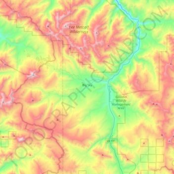
Name: Big Sky topographic map, elevation, terrain.
Location: Big Sky, Gallatin County, Montana, 59716, United States (45.13076 -111.49439 45.37939 -111.03817)
Average elevation: 7,989 ft
Minimum elevation: 5,541 ft
Maximum elevation: 11,096 ft
Gallatin County trails, hiking, mountain biking, running and outdoor activities
Other topographic maps
Click on a map to view its topography, its elevation and its terrain.



Gallatin Gateway
United States > Montana > Gallatin County
Gallatin Gateway is a census-designated place (CDP) in Gallatin County, Montana, United States. As of the 2020 census, Gallatin Gateway had a population of 967. Elevation is 4,953 ft (1,510 m).
Average elevation: 4,984 ft