
Make a donation
Gear up for your next adventure:
As an Amazon Associate, this site earns from qualifying purchases at no extra cost to you.
Gallatin Gateway topographic map
Click on the map to display elevation.
Make a donation
Gear up for your next adventure:
As an Amazon Associate, this site earns from qualifying purchases at no extra cost to you.
Gallatin Gateway
Gallatin Gateway is a census-designated place (CDP) in Gallatin County, Montana, United States. As of the 2020 census, Gallatin Gateway had a population of 967. Elevation is 4,953 ft (1,510 m).
Make a donation
Gear up for your next adventure:
As an Amazon Associate, this site earns from qualifying purchases at no extra cost to you.
About this map
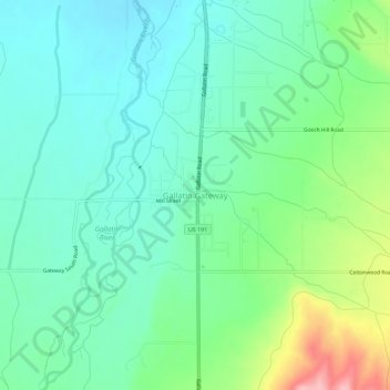
Name: Gallatin Gateway topographic map, elevation, terrain.
Location: Gallatin Gateway, Gallatin County, Montana, United States (45.57161 -111.21742 45.61161 -111.17742)
Average elevation: 4,984 ft
Minimum elevation: 4,852 ft
Maximum elevation: 5,338 ft
Make a donation
Gear up for your next adventure:
As an Amazon Associate, this site earns from qualifying purchases at no extra cost to you.
Other topographic maps
Click on a map to view its topography, its elevation and its terrain.
Big Sky
United States > Montana > Gallatin County
Big Sky is characterized by its dramatic and diverse topography, which forms part of the northern Rocky Mountains. The area features an elevation that ranges from around 5,500 feet in the valleys to more than 11,000 feet at its peaks, including the notable Lone Peak. This mountainous terrain is interspersed…
Average elevation: 7,989 ft
Bozeman
United States > Montana > Gallatin County
Bozeman is located at an elevation of 4,820 feet (1,470 m). The Bridger Mountains are to the north-northeast, the Tobacco Root Mountains to the west-southwest, the Big Belt Mountains and Horseshoe Hills to the northwest, the Hyalite Peaks of the northern Gallatin Range to the south and the Spanish Peaks of the…
Average elevation: 4,905 ft
Make a donation
Gear up for your next adventure:
As an Amazon Associate, this site earns from qualifying purchases at no extra cost to you.
Bozeman
United States > Montana > Gallatin County
Bozeman is located at an elevation of 4,820 feet (1,470 m). The Bridger Mountains are to the north-northeast, the Tobacco Root Mountains to the west-southwest, the Big Belt Mountains and Horseshoe Hills to the northwest, the Hyalite Peaks of the northern Gallatin Range to the south and the Spanish Peaks of the…
Average elevation: 4,905 ft
Big Sky
United States > Montana > Gallatin County
Big Sky is located close to the Yellowstone National Park along the western edge of Gallatin County and eastern edge of Madison County, on U.S. Highway 191. It is approximately midway between West Yellowstone and Bozeman, being around 45 miles (72 km) by road from each. It sits within the Madison Range, with…
Average elevation: 8,002 ft
Make a donation
Gear up for your next adventure:
As an Amazon Associate, this site earns from qualifying purchases at no extra cost to you.
Bozeman
United States > Montana > Gallatin County
Bozeman is located at an elevation of 4,820 feet or 1,470 metres. The Bridger Mountains are to the north-northeast, the Tobacco Root Mountains to the west-south-west, the Big Belt Mountains and Horseshoe Hills to the northwest, the Hyalite Peaks of the northern Gallatin Range to the south and the Spanish Peaks…
Average elevation: 4,905 ft