
Puerto Natales topographic map
Click on the map to display elevation.
About this map
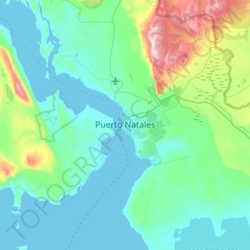
Name: Puerto Natales topographic map, elevation, terrain.
Average elevation: 463 ft
Minimum elevation: -10 ft
Maximum elevation: 3,068 ft
Other topographic maps
Click on a map to view its topography, its elevation and its terrain.
Isla García
Chile > Magallanes and Chilean Antarctica Region > Provincia de Última Esperanza
Average elevation: 85 ft
Torres del Paine
Chile > Magallanes and Chilean Antarctica Region > Provincia de Última Esperanza
Average elevation: 2,090 ft
Isla Madre de Dios
Chile > Magallanes and Chilean Antarctica Region > Provincia de Última Esperanza
Average elevation: 344 ft
Hanover Island
Chile > Magallanes and Chilean Antarctica Region > Provincia de Última Esperanza
Average elevation: 486 ft
Torres del Paine
Chile > Magallanes and Chilean Antarctica Region > Provincia de Última Esperanza
Average elevation: 2,090 ft
Mornington Island
Chile > Magallanes and Chilean Antarctica Region > Provincia de Última Esperanza
Average elevation: 207 ft
Brüggen Glacier
Chile > Magallanes and Chilean Antarctica Region > Provincia de Última Esperanza
Average elevation: 4,144 ft
Dickson Lake
Chile > Magallanes and Chilean Antarctica Region > Provincia de Última Esperanza > Torres del Paine
Average elevation: 2,703 ft
Isla Jorge Montt
Chile > Magallanes and Chilean Antarctica Region > Provincia de Última Esperanza
Average elevation: 440 ft
Isla Chatham
Chile > Magallanes and Chilean Antarctica Region > Provincia de Última Esperanza
Average elevation: 531 ft
Isla Valenzuela
Chile > Magallanes and Chilean Antarctica Region > Provincia de Última Esperanza
Average elevation: 456 ft
Isla Cabrera
Chile > Magallanes and Chilean Antarctica Region > Provincia de Última Esperanza
Average elevation: 262 ft
Mornington Island
Chile > Magallanes and Chilean Antarctica Region > Provincia de Última Esperanza
Average elevation: 207 ft
Valle Ascensio
Chile > Magallanes and Chilean Antarctica Region > Provincia de Última Esperanza > Torres del Paine
Average elevation: 3,478 ft
Duke of York Island
Chile > Magallanes and Chilean Antarctica Region > Provincia de Última Esperanza
Average elevation: 213 ft
Torres del Paine
Chile > Magallanes and Chilean Antarctica Region > Provincia de Última Esperanza
Average elevation: 2,090 ft
Torres del Paine
Chile > Magallanes and Chilean Antarctica Region > Provincia de Última Esperanza
Average elevation: 2,090 ft
Glaciar Spegazzini Ramal Sur
Chile > Magallanes and Chilean Antarctica Region > Provincia de Última Esperanza
Average elevation: 5,449 ft
Torres del Paine
Chile > Magallanes and Chilean Antarctica Region > Provincia de Última Esperanza
Average elevation: 2,090 ft