Geolocate

Paducah topographic map

Click on the map to display elevation.

About this map

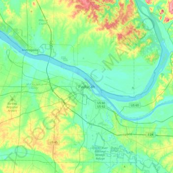
Name: Paducah topographic map, elevation, terrain.

Location: Paducah, McCracken County, Kentucky, 42002, United States (36.92339 -88.76005 37.24339 -88.44005)

Average elevation: 384 ft

Minimum elevation: 302 ft

Maximum elevation: 623 ft

McCracken County trails, hiking, mountain biking, running and outdoor activities

Gear up for your next adventure:

🔭Telescopic Hiking Pole - Adjustable pole for hiking stability
📖Nature Tracking Books - Learn to track wildlife and terrain
🌧️Backpack Rain Cover - Keep gear dry in wet weather
🥩Freeze-Dried Meals - Nutritious and lightweight food for remote expeditions
🚪Portable Camp Chair - Foldable chair for comfort at camp

As an Amazon Associate, this site earns from qualifying purchases at no extra cost to you.