Geolocate

Sankt Englmar topographic map

Click on the map to display elevation.

About this map

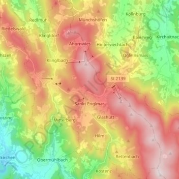
Name: Sankt Englmar topographic map, elevation, terrain.

Location: Sankt Englmar, Landkreis Straubing-Bogen, Bavaria, 94379, Germany (48.96217 12.77019 49.05506 12.88063)

Average elevation: 2,336 ft

Minimum elevation: 1,191 ft

Maximum elevation: 3,547 ft

Other topographic maps

Click on a map to view its topography, its elevation and its terrain.

Heilbrunn

Germany > Bavaria > Landkreis Straubing-Bogen

Average elevation: 2,113 ft

Rotham

Germany > Bavaria > Landkreis Straubing-Bogen > Steinach

Average elevation: 1,109 ft

Metting

Germany > Bavaria > Landkreis Straubing-Bogen

Average elevation: 1,273 ft

Maibrunn

Germany > Bavaria > Landkreis Straubing-Bogen > Klinglbach

Average elevation: 2,408 ft

Welchenberg

Germany > Bavaria > Landkreis Straubing-Bogen

Average elevation: 1,076 ft

Gear up for your next adventure:

🧥Waterproof Jacket for Hiking - Breathable and rugged rain jacket for outdoor excursions
📶Satellite Messenger - Communication device off‑grid
🕶️GPS Smartphone Mount - Secure mount for phone navigation
🌄Hiking Binoculars - Compact binoculars for scenic views and trail spotting
🧭Orienteering Set - Complete compass and map reading kit

As an Amazon Associate, this site earns from qualifying purchases at no extra cost to you.