Geolocate

Quincy topographic map

Click on the map to display elevation.

About this map

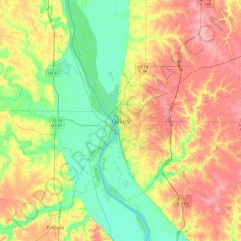
Name: Quincy topographic map, elevation, terrain.

Location: Quincy, Adams County, Illinois, 62301, United States (39.77560 -91.56987 40.09560 -91.24987)

Average elevation: 594 ft

Minimum elevation: 440 ft

Maximum elevation: 791 ft

Adams County trails, hiking, mountain biking, running and outdoor activities

Gear up for your next adventure:

🦶Carbon Trekking Poles - Reduce knee impact on steep descents with ultra-light poles
🌎3D Topographic Globes - Raised relief globes for a tactile understanding of geography
📻Weather Alert Radios - Stay informed of storm risks while off-the-grid
🚑Emergency Bivvies - Heat-reflective sleeping bags for survival situations
🥇GPS Hiking Watch - Multi‑sport GPS watch with navigation and trail tracking

As an Amazon Associate, this site earns from qualifying purchases at no extra cost to you.