
Make a donation
Gear up for your next adventure:
As an Amazon Associate, this site earns from qualifying purchases at no extra cost to you.
Lyons topographic map
Click on the map to display elevation.
Make a donation
Gear up for your next adventure:
As an Amazon Associate, this site earns from qualifying purchases at no extra cost to you.
About this map
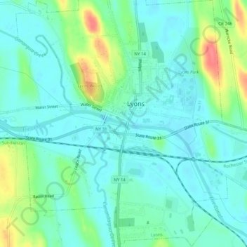
Name: Lyons topographic map, elevation, terrain.
Location: Lyons, Wayne County, New York, United States (43.04323 -77.01436 43.07942 -76.97178)
Average elevation: 440 ft
Minimum elevation: 384 ft
Maximum elevation: 594 ft
Wayne County trails, hiking, mountain biking, running and outdoor activities
Make a donation
Gear up for your next adventure:
As an Amazon Associate, this site earns from qualifying purchases at no extra cost to you.
Other topographic maps
Click on a map to view its topography, its elevation and its terrain.
Make a donation
Gear up for your next adventure:
As an Amazon Associate, this site earns from qualifying purchases at no extra cost to you.
East Williamson
United States > New York > Wayne County > Town of Williamson
Average elevation: 436 ft