
Thank you for supporting this site ❤️
Make a donation
Make a donation
Gear up for your next adventure:
As an Amazon Associate, this site earns from qualifying purchases at no extra cost to you.
Tupac Amaru II topographic map
Click on the map to display elevation.
Thank you for supporting this site ❤️
Make a donation
Make a donation
Gear up for your next adventure:
As an Amazon Associate, this site earns from qualifying purchases at no extra cost to you.
About this map
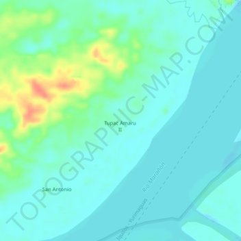
Name: Tupac Amaru II topographic map, elevation, terrain.
Location: Tupac Amaru II, Nauta, Loreto, 16301, Perú (-4.56237 -73.62847 -4.52237 -73.58847)
Average elevation: 312 ft
Minimum elevation: 276 ft
Maximum elevation: 433 ft
Thank you for supporting this site ❤️
Make a donation
Make a donation
Gear up for your next adventure:
As an Amazon Associate, this site earns from qualifying purchases at no extra cost to you.
Other topographic maps
Click on a map to view its topography, its elevation and its terrain.
Área de Conservación Privada Comunidad Nativa San Jorge del Río Marañón
Average elevation: 410 ft