Geolocate

Jasper topographic map

Click on the map to display elevation.

About this map

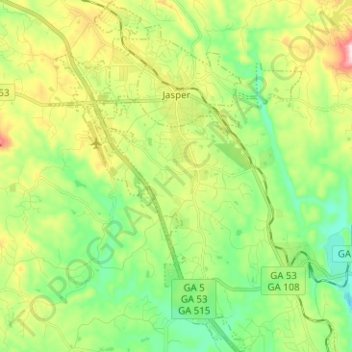
Name: Jasper topographic map, elevation, terrain.

Location: Jasper, Pickens County, Georgia, 30142, United States (34.39175 -84.47465 34.49531 -84.38435)

Average elevation: 1,339 ft

Minimum elevation: 912 ft

Maximum elevation: 2,119 ft

Pickens County trails, hiking, mountain biking, running and outdoor activities

Other topographic maps

Click on a map to view its topography, its elevation and its terrain.

Jasper City Park

United States > Georgia > Pickens County > Jasper

Average elevation: 1,398 ft

Gear up for your next adventure:

🚑Emergency Bivvies - Heat-reflective sleeping bags for survival situations
🎒Hydration Pack - Hands‑free water reservoir for long hikes
💧Water Filtration Bottles - Safely drink from streams and lakes while exploring
🔪Outdoor Multitools - Essential survival tools for gear repair and field use
🪄Magnetic Compass - Accurate compass for navigation

As an Amazon Associate, this site earns from qualifying purchases at no extra cost to you.