
Thank you for supporting this site ❤️
Make a donation
Make a donation
Gear up for your next adventure:
As an Amazon Associate, this site earns from qualifying purchases at no extra cost to you.
Gandria topographic map
Click on the map to display elevation.
Thank you for supporting this site ❤️
Make a donation
Make a donation
Gear up for your next adventure:
As an Amazon Associate, this site earns from qualifying purchases at no extra cost to you.
About this map
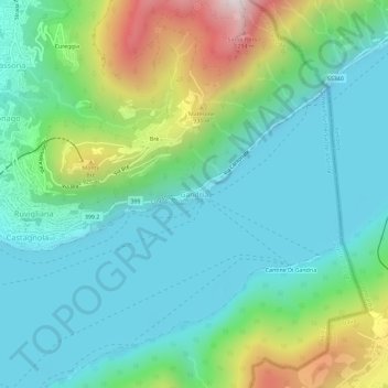
Name: Gandria topographic map, elevation, terrain.
Location: Gandria, Lugano, Distretto di Lugano, Ticino, 6978, Switzerland (45.98574 8.98278 46.02574 9.02278)
Average elevation: 1,749 ft
Minimum elevation: 804 ft
Maximum elevation: 4,495 ft
Thank you for supporting this site ❤️
Make a donation
Make a donation
Gear up for your next adventure:
As an Amazon Associate, this site earns from qualifying purchases at no extra cost to you.
Other topographic maps
Click on a map to view its topography, its elevation and its terrain.
Parco Civico Villa Ciani
Switzerland > Ticino > Distretto di Lugano > Lugano
Average elevation: 1,027 ft