Geolocate

Province of Huanta topographic map

Click on the map to display elevation.

About this map

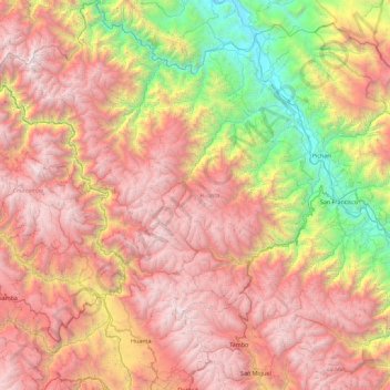
Name: Province of Huanta topographic map, elevation, terrain.

Location: Province of Huanta, Ayacucho, Peru (-13.05125 -74.58118 -12.16747 -73.82992)

Average elevation: 8,799 ft

Minimum elevation: 1,460 ft

Maximum elevation: 16,063 ft

Other topographic maps

Click on a map to view its topography, its elevation and its terrain.

Atacocha

Peru > Ayacucho

Average elevation: 10,581 ft

Mejorada

Peru > Ayacucho > Unión Progreso

Average elevation: 3,885 ft

Palmadera

Peru > Ayacucho

Average elevation: 12,231 ft

Guitarrayoc

Peru > Ayacucho > Uspa

Average elevation: 4,974 ft

Santa Rosa

Peru > Ayacucho > San Juan Bautista

Average elevation: 9,160 ft

Guitarrayoc

Peru > Ayacucho > Uspa

Average elevation: 4,974 ft

Unya

Peru > Ayacucho

Average elevation: 9,603 ft

Pampas

Peru > Ayacucho > Luis Carranza

Average elevation: 10,062 ft

Cancha Cancha

Peru > Ayacucho

Average elevation: 11,050 ft

Tambobamba

Peru > Ayacucho

Average elevation: 9,724 ft

La Vega

Peru > Ayacucho

Average elevation: 9,459 ft

Apachita

Peru > Ayacucho > Vilcas Huamán > Alto Perú > Apachita

Average elevation: 11,483 ft

Villa Virgen

Peru > Ayacucho > Llochegua

Average elevation: 2,060 ft

Gear up for your next adventure:

Solar GPS Watches - Advanced multisport watches with built-in topographic maps
🗃️Trail First Aid Kit - Essential kit for outdoor injuries and emergencies
🧣Hiking Neck Gaiter - Multi‑use neck protection for outdoor weather
🌡️Handheld Weather Meters - Measure wind, temp, and pressure for safe mountain travel
🧺Microfiber Travel Towels - Compact and fast-drying towels for trail use

As an Amazon Associate, this site earns from qualifying purchases at no extra cost to you.