
Thorp topographic map
Click on the map to display elevation.
Thorp
The town of Thorp is 100 miles (160 km) east of Seattle, 8 miles (13 km) northwest of Ellensburg, and 17 miles (27 km) southeast of Cle Elum. It is located at the narrow west end of the Kittitas Valley, where high elevation forests of the Cascade Range give way to cattle ranches surrounded by farmlands noted for timothy hay, alfalfa, vegetables, and fruit production.
About this map
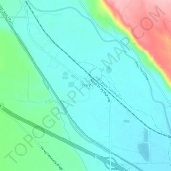
Name: Thorp topographic map, elevation, terrain.
Location: Thorp, Kittitas County, Washington, United States (47.05327 -120.69378 47.08248 -120.64984)
Average elevation: 1,709 ft
Minimum elevation: 1,594 ft
Maximum elevation: 2,087 ft
Kittitas County trails, hiking, mountain biking, running and outdoor activities
Other topographic maps
Click on a map to view its topography, its elevation and its terrain.
Cathedral Rock
United States > Washington > Kittitas County
Cathedral Rock is an intrusive andesite volcanic complex. The Alpine Lakes Wilderness features some of the most rugged topography in the Cascade Range with craggy peaks and ridges, deep glacial valleys, and granite walls spotted with over 700 mountain lakes. Geological events occurring many years ago created…
Average elevation: 5,075 ft
Hyak
United States > Washington > Kittitas County
Hyak is located two miles (3 km) east of the summit of Snoqulamie Pass at an elevation of 2,600 feet (790 m). It is 16 miles (26 km) northwest of Easton and is part of the Easton school district.
Average elevation: 2,976 ft
Cathedral Rock
United States > Washington > Kittitas County
Cathedral Rock is an intrusive andesite volcanic complex. The Alpine Lakes Wilderness features some of the most rugged topography in the Cascade Range with craggy peaks and ridges, deep glacial valleys, and granite walls spotted with over 700 mountain lakes. Geological events occurring many years ago created…
Average elevation: 5,075 ft