
Boughrood topographic map
Click on the map to display elevation.
About this map
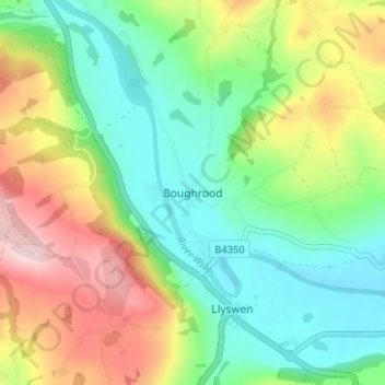
Name: Boughrood topographic map, elevation, terrain.
Location: Boughrood, Powys, Wales, LD3 0YG, United Kingdom (52.02544 -3.29225 52.06544 -3.25225)
Average elevation: 577 ft
Minimum elevation: 279 ft
Maximum elevation: 1,093 ft
Other topographic maps
Click on a map to view its topography, its elevation and its terrain.
Brecon Beacons National Park
United Kingdom > Wales > Powys
Brecon Beacons National Park, officially named Bannau Brycheiniog National Park (Welsh pronunciation), is a national park in Wales. It is named after the Brecon Beacons (Welsh: Bannau Brycheiniog), the mountain range at its centre. The national park includes the highest mountain in South Wales, Pen y Fan,…
Average elevation: 886 ft