
Make a donation
Gear up for your next adventure:
As an Amazon Associate, this site earns from qualifying purchases at no extra cost to you.
Albany topographic map
Click on the map to display elevation.
Make a donation
Gear up for your next adventure:
As an Amazon Associate, this site earns from qualifying purchases at no extra cost to you.
Albany
Albany is located in south-central Clinton County at 36°41′36″N 85°8′7″W / 36.69333°N 85.13528°W / 36.69333; -85.13528 (36.693280, -85.135286). The city lies at an elevation of 960 feet (290 m) at the foot of the western edge of the Cumberland Plateau. Albany Rock, a western spur of the plateau, rises northeast of the city to an elevation of 1,700 feet (520 m).
Make a donation
Gear up for your next adventure:
As an Amazon Associate, this site earns from qualifying purchases at no extra cost to you.
About this map
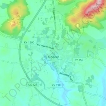
Name: Albany topographic map, elevation, terrain.
Location: Albany, Clinton County, Kentucky, 42602, United States (36.66703 -85.14949 36.72039 -85.11631)
Average elevation: 1,017 ft
Minimum elevation: 830 ft
Maximum elevation: 1,716 ft
Clinton County trails, hiking, mountain biking, running and outdoor activities
Make a donation
Gear up for your next adventure:
As an Amazon Associate, this site earns from qualifying purchases at no extra cost to you.
Other topographic maps
Click on a map to view its topography, its elevation and its terrain.