
Thank you for supporting this site ❤️
Make a donation
Make a donation
Gear up for your next adventure:
As an Amazon Associate, this site earns from qualifying purchases at no extra cost to you.
Roka topographic map
Click on the map to display elevation.
Thank you for supporting this site ❤️
Make a donation
Make a donation
Gear up for your next adventure:
As an Amazon Associate, this site earns from qualifying purchases at no extra cost to you.
About this map
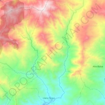
Name: Roka topographic map, elevation, terrain.
Location: Roka, Distrito Müna, Ngäbe-Buglé, Panama (8.41662 -81.65705 8.57572 -81.57940)
Average elevation: 3,570 ft
Minimum elevation: 1,033 ft
Maximum elevation: 7,224 ft
Thank you for supporting this site ❤️
Make a donation
Make a donation
Gear up for your next adventure:
As an Amazon Associate, this site earns from qualifying purchases at no extra cost to you.