
Kandhi topographic map
Interactive map
Click on the map to display elevation.
About this map
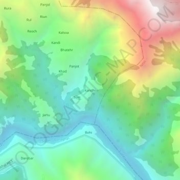
Name: Kandhi topographic map, elevation, terrain.
Location: Kandhi, Sundarnagar, Mandi, Himachal Pradesh, India (31.35227 76.90020 31.39227 76.94020)
Average elevation: 3,681 ft
Minimum elevation: 1,749 ft
Maximum elevation: 7,694 ft
Other topographic maps
Click on a map to view its topography, its elevation and its terrain.
Banaik
India > Himachal Pradesh > Sundarnagar > Banaik
Banaik, Sundarnagar, Mandi, Himachal Pradesh, 175019, India
Average elevation: 3,084 ft