
Make a donation
Gear up for your next adventure:
As an Amazon Associate, this site earns from qualifying purchases at no extra cost to you.
Diedesheim topographic map
Click on the map to display elevation.
Make a donation
Gear up for your next adventure:
As an Amazon Associate, this site earns from qualifying purchases at no extra cost to you.
Diedesheim
Immer wieder wurde Diedesheim Opfer von Hochwasserereignissen. Der höchste je gemessene Pegelstand des Neckar war 8,95 m am 21. Dezember 1993 (Mittelwert 1994–2003: 2,36 m). Jedoch ist dieser Pegelstand nur der höchste seit Beginn der Messungen. Wie man Hochwassermarken entnehmen kann, müssen die Pegelstände des 28. Dezember 1882 und 30. Oktober 1884 wesentlich höher gewesen sein.
Make a donation
Gear up for your next adventure:
As an Amazon Associate, this site earns from qualifying purchases at no extra cost to you.
About this map
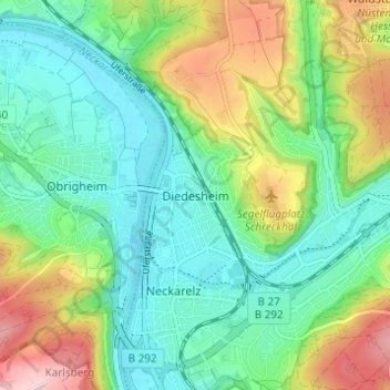
Name: Diedesheim topographic map, elevation, terrain.
Average elevation: 666 ft
Minimum elevation: 430 ft
Maximum elevation: 1,165 ft
Make a donation
Gear up for your next adventure:
As an Amazon Associate, this site earns from qualifying purchases at no extra cost to you.
Other topographic maps
Click on a map to view its topography, its elevation and its terrain.
Sattelbach
Deutschland > Baden-Württemberg > Neckar-Odenwald-Kreis > Mosbach > Sattelbach
Average elevation: 988 ft
74821
Deutschland > Baden-Württemberg > Neckar-Odenwald-Kreis > Mosbach > Lohrbach
Average elevation: 1,001 ft