Geolocate

Bala Lake topographic map

Click on the map to display elevation.

About this map

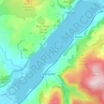
Name: Bala Lake topographic map, elevation, terrain.

Location: Bala Lake, Llangywer, Gwynedd, Wales, United Kingdom (52.86422 -3.65308 52.90608 -3.59308)

Average elevation: 807 ft

Minimum elevation: 518 ft

Maximum elevation: 1,585 ft

Other topographic maps

Click on a map to view its topography, its elevation and its terrain.

Rhos-y-gwaliau

United Kingdom > Wales > Gwynedd > Llangywer

Average elevation: 807 ft

Hirnant

United Kingdom > Wales > Gwynedd > Llangywer

Average elevation: 1,253 ft

Rhos-y-gwaliau

United Kingdom > Wales > Gwynedd > Llangywer

Average elevation: 807 ft

Gear up for your next adventure:

👓Polarized Sunglasses - Outdoor sunglasses for glare reduction
📖Nature Tracking Books - Learn to track wildlife and terrain
🎒Waterproof Dry Bags - Keep your electronics and maps dry inside your pack
🧭Map Reading Tools - Tools and kits for map navigation
📦Gear Storage Bags - Organize and protect outdoor equipment

As an Amazon Associate, this site earns from qualifying purchases at no extra cost to you.