
Make a donation
Gear up for your next adventure:
As an Amazon Associate, this site earns from qualifying purchases at no extra cost to you.
Patacamaya topographic map
Click on the map to display elevation.
Make a donation
Gear up for your next adventure:
As an Amazon Associate, this site earns from qualifying purchases at no extra cost to you.
Patacamaya
Patacamaya se encuentra a una altitud de 3.800 metros sobre el nivel del mar. En cuanto a distancia, Patacamaya se encuentra a 98 km de La Paz, la capital departamental, y a 131 km de Oruro. La capital del municipio forma parte de la Ruta Nacional 1 de Bolivia, que es doble vía.
Make a donation
Gear up for your next adventure:
As an Amazon Associate, this site earns from qualifying purchases at no extra cost to you.
About this map
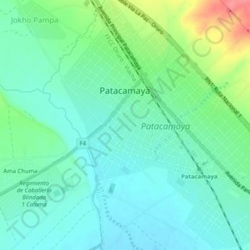
Name: Patacamaya topographic map, elevation, terrain.
Location: Patacamaya, Provincia Aroma, La Paz, Bolivia (-17.25473 -67.92922 -17.22020 -67.89562)
Average elevation: 12,464 ft
Minimum elevation: 12,395 ft
Maximum elevation: 12,644 ft
Make a donation
Gear up for your next adventure:
As an Amazon Associate, this site earns from qualifying purchases at no extra cost to you.