
Kfardebian topographic map
Click on the map to display elevation.
Kfardebian
Kfardebian (Arabic: كفر دبيان; also spelled Kfar Dibiane and also known as Moucha'a Keserwan) is a municipality in the Keserwan District of the Keserwan-Jbeil Governorate in Lebanon. It is located 45 kilometers north of Beirut. Its average elevation is 1,220 meters above sea level and its total land area is 2,960 hectares. Kfardebian inhabitants are predominantly Melkite and Maronite Christians.
About this map
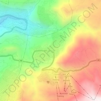
Name: Kfardebian topographic map, elevation, terrain.
Average elevation: 5,768 ft
Minimum elevation: 4,091 ft
Maximum elevation: 7,543 ft
Other topographic maps
Click on a map to view its topography, its elevation and its terrain.
Rayfoun
Lebanon > Keserwan-Jbeil Governorate
Rayfoun (Arabic: ريفون; also spelled Reifun or Raifoun) is a village and municipality located in the Keserwan District of the Keserwan-Jbeil Governorate of Lebanon. The village is about 28 kilometres (17 mi) north of Beirut. It has an average elevation of 1,050 meters above sea level and a total land area…
Average elevation: 3,248 ft
Ghazir
Lebanon > Keserwan-Jbeil Governorate
Ghazir (Arabic: غزير) is a town and municipality in the Keserwan District of the Keserwan-Jbeil Governorate of Lebanon. It is located 27 kilometres (17 mi) north of Beirut. It has an average elevation of 380 meters above sea level and a total land area of 542 hectares (2.09 sq mi).
Average elevation: 1,178 ft