Geolocate

Sanguem topographic map

Click on the map to display elevation.

Sanguem

Sanguem is located at 15°14′N 74°10′E / 15.23°N 74.17°E / 15.23; 74.17. It has an average elevation of 22 metres (72 feet).

Wikipedia (CC-BY-SA 3.0)

About this map

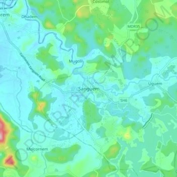
Name: Sanguem topographic map, elevation, terrain.

Location: Sanguem, South Goa, Goa, 403704, India (15.18827 74.11127 15.26827 74.19127)

Average elevation: 138 ft

Minimum elevation: 7 ft

Maximum elevation: 787 ft

Other topographic maps

Click on a map to view its topography, its elevation and its terrain.

Sanvordem

India > Goa > Sanguem

Average elevation: 92 ft

Salaulim Dam

India > Goa > Sanguem > Sanguem

Average elevation: 128 ft

Maulinguem

India > Goa > Sanguem

Average elevation: 331 ft

Gear up for your next adventure:

🧯Portable Fire Pit - Compact fire pit for camping spots
Solar GPS Watches - Advanced multisport watches with built-in topographic maps
🧭Hiking Compass - Precision compass for reliable navigation in the wilderness
🥾Women's Hiking Boots - Top-rated trail boots with ankle support and superior grip
🧭Compass with Lanyard - Easy‑carry compass for navigation

As an Amazon Associate, this site earns from qualifying purchases at no extra cost to you.