Geolocate

Challapalca topographic map

Click on the map to display elevation.

About this map

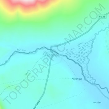
Name: Challapalca topographic map, elevation, terrain.

Location: Challapalca, Tarata, Tacna, Perú (-17.25466 -69.81512 -17.21466 -69.77512)

Average elevation: 14,121 ft

Minimum elevation: 13,914 ft

Maximum elevation: 15,174 ft

Gear up for your next adventure:

🔪Outdoor Multitools - Essential survival tools for gear repair and field use
🌲Outdoor Survival Books - Best books on survival skills
🪶Fire Starter Kit - Reliable fire starter for survival and camping
😴Insulated Sleeping Pads - Compact and warm pads for high-elevation camping
🧴Hand Sanitizer - Keep hands clean while hiking

As an Amazon Associate, this site earns from qualifying purchases at no extra cost to you.