
Make a donation
Gear up for your next adventure:
As an Amazon Associate, this site earns from qualifying purchases at no extra cost to you.
Halmaal topographic map
Click on the map to display elevation.
Make a donation
Gear up for your next adventure:
As an Amazon Associate, this site earns from qualifying purchases at no extra cost to you.
Halmaal
Halmaal ligt in Vochtig-Haspengouw, in de vallei van de Molenbeek. De hoogte bedraagt ongeveer 45 meter. Ten zuiden van Halmaal loopt van oost naar west een oude Romeins heerbaan, de Romeinse Steenweg genaamd. Deze is onderdeel van de heerbaan van Tongeren naar Boulogne-sur-Mer.
Make a donation
Gear up for your next adventure:
As an Amazon Associate, this site earns from qualifying purchases at no extra cost to you.
About this map
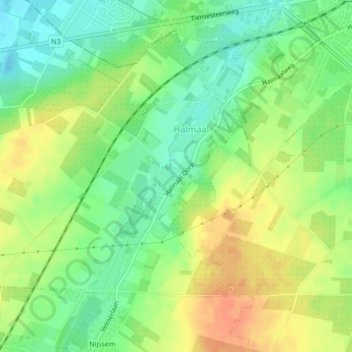
Name: Halmaal topographic map, elevation, terrain.
Location: Halmaal, Sint-Truiden, Hasselt, Limburg, België (50.79198 5.13269 50.80948 5.16016)
Average elevation: 200 ft
Minimum elevation: 135 ft
Maximum elevation: 272 ft
Make a donation
Gear up for your next adventure:
As an Amazon Associate, this site earns from qualifying purchases at no extra cost to you.
Other topographic maps
Click on a map to view its topography, its elevation and its terrain.
Make a donation
Gear up for your next adventure:
As an Amazon Associate, this site earns from qualifying purchases at no extra cost to you.
Make a donation
Gear up for your next adventure:
As an Amazon Associate, this site earns from qualifying purchases at no extra cost to you.