
Make a donation
Gear up for your next adventure:
As an Amazon Associate, this site earns from qualifying purchases at no extra cost to you.
Eibenstock topographic map
Click on the map to display elevation.
Make a donation
Gear up for your next adventure:
As an Amazon Associate, this site earns from qualifying purchases at no extra cost to you.
Eibenstock
Aufgrund der Höhenlage von mehr als 600 m wird Eibenstock nicht zu den allerersten Bauerndörfern im Erzgebirge gehört haben. Es gibt die Einschätzung, es sei als dauerhafte Ansiedlung in Form eines Radialwaldhufendorfes frühestens im Laufe des 13. Jahrhunderts im Bereich der späteren Herrschaft Schwarzenberg entstanden. Ab Ende des 12. Jahrhunderts wird es bereits als Bauerndorf angesehen. In etwa 1,5 Kilometern Entfernung vom Stadtrand wurde unweit der Mündung des Steinbächels in die Große Bockau bei Blauenthal ein Ringwall gefunden.
Make a donation
Gear up for your next adventure:
As an Amazon Associate, this site earns from qualifying purchases at no extra cost to you.
About this map
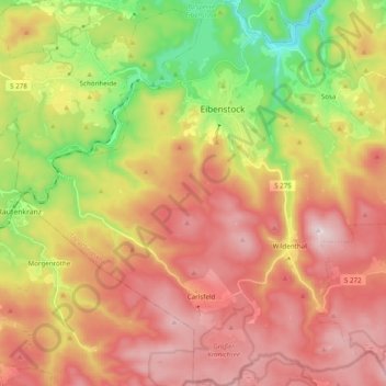
Name: Eibenstock topographic map, elevation, terrain.
Location: Eibenstock, Erzgebirgskreis, Sachsen, 08309, Deutschland (50.40560 12.49587 50.53002 12.66706)
Average elevation: 2,464 ft
Minimum elevation: 1,476 ft
Maximum elevation: 3,330 ft
Make a donation
Gear up for your next adventure:
As an Amazon Associate, this site earns from qualifying purchases at no extra cost to you.