
Make a donation
Gear up for your next adventure:
As an Amazon Associate, this site earns from qualifying purchases at no extra cost to you.
Donnersberg topographic map
Click on the map to display elevation.
Make a donation
Gear up for your next adventure:
As an Amazon Associate, this site earns from qualifying purchases at no extra cost to you.
Donnersberg
Das Donnersbergmassiv hat eine Grundfläche von rund 24 km². In Nordost-Südwest-Richtung ist es zwischen Bastenhaus und Imsbach 7 km lang und in Nordwest-Südost-Richtung zwischen dem Marienthaler Mordkammerhof und dem Steinbacher Wohnplatz Haus Kaiserbusch 4,5 km breit. Sein Gipfel (686,5 m) erhebt sich 344 m über dem Gelände der auf 342,5 m Höhe stehenden Marienthaler Kirche und 410,5 m über jenem der auf 276 m Höhe stehenden Steinbacher Kirche.
Make a donation
Gear up for your next adventure:
As an Amazon Associate, this site earns from qualifying purchases at no extra cost to you.
About this map
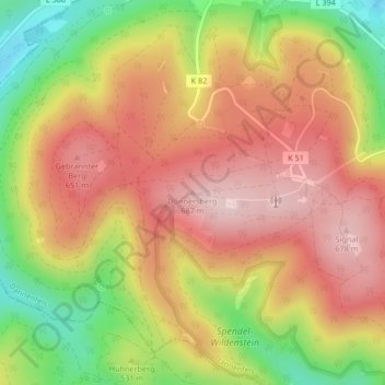
Name: Donnersberg topographic map, elevation, terrain.
Average elevation: 1,801 ft
Minimum elevation: 1,198 ft
Maximum elevation: 2,254 ft
Make a donation
Gear up for your next adventure:
As an Amazon Associate, this site earns from qualifying purchases at no extra cost to you.