
Doradal topographic map
Click on the map to display elevation.
About this map
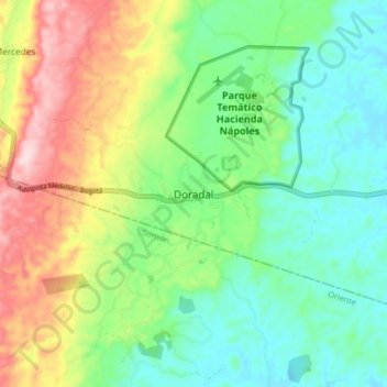
Name: Doradal topographic map, elevation, terrain.
Average elevation: 837 ft
Minimum elevation: 528 ft
Maximum elevation: 1,411 ft
Other topographic maps
Click on a map to view its topography, its elevation and its terrain.
Medellín
Medellín has 16 comunas (districts), 5 corregimientos (townships), and 271 barrios (neighborhoods). The metropolitan area of Medellín lies within the Aburrá valley at an elevation of 1,500 meters (4,900 feet) above sea level and is bisected by the Medellín River (also called Porce), which flows northward.…
Average elevation: 6,795 ft
Comuna 14 - El Poblado
Colombia > Antioquia > Medellín
El Poblado consists of 1,432.58 hectares (3,540.0 acres), encompassing 39% of the Medellín municipality. It is located in the southeastern zone of the city towards the mountains of the Aburrá Valley. The Medellín River borders its western side, separating it from the Guayabal Commune and its elevation east…
Average elevation: 5,682 ft
Medellín
Medellín has 16 comunas (districts), 5 corregimientos (townships), and 271 barrios (neighborhoods). The metropolitan area of Medellín lies within the Aburrá valley at an elevation of 1,500 meters (4,900 feet) above sea level and is bisected by the Medellín River (also called Porce), which flows northward.…
Average elevation: 6,175 ft
Medellín
Medellín has 16 comunas (districts), 5 corregimientos (townships), and 271 barrios (neighborhoods). The metropolitan area of Medellín lies within the Aburrá valley at an elevation of 1,500 meters (4,900 feet) above sea level and is bisected by the Medellín River (also called Porce), which flows northward.…
Average elevation: 6,795 ft
Santa Fe de Antioquia
The climate of Santa Fe de Antioquia is tropical and humid, typical of Colombia's Cauca River valley, due to its low altitude and its geographical location near the equator. The average temperature is 25.5 °C (77.9 °F) throughout the year. This pleasant weather has allowed tourism to develop in the city,…
Average elevation: 5,348 ft
La Pintada
La Pintada (Spanish pronunciation: [la pinˈtaða]); is a town and municipality in the southwest region of the Antioquia department. It is located 79 miles from Medellín at an altitude of 600 m (2,000 ft) above sea level. It borders the Fredonia and Santa Bárbara municipalities to the north. The Cauca River…
Average elevation: 2,677 ft
Concepción
Concepción has a cool tropical rainforest climate (Af) due to altitude. It has very heavy rainfall year-round.
Average elevation: 6,640 ft
Concepción
Concepción has a cool tropical rainforest climate (Af) due to altitude. It has very heavy rainfall year-round.
Average elevation: 6,640 ft
Ciénaga La Popa
Colombia > Antioquia > Yondó > San Miguel del Tigre > El Tigre
Average elevation: 236 ft
La Unión
The locality is part of the Altiplano zone and is located in the highest part of the south of the San Nicolás Valley. The municipality has a complex mountain system, allowing it to have several thermal floors: of its total extension of 198 km², 136 km² comprise a cold climate (including the north, east, and…
Average elevation: 7,907 ft
Medellín
Medellín has 16 comunas (districts), 5 corregimientos (townships), and 271 barrios (neighborhoods). The metropolitan area of Medellín lies within the Aburrá valley at an elevation of 1,500 meters (4,900 feet) above sea level and is bisected by the Medellín River (also called Porce), which flows northward.…
Average elevation: 6,795 ft
Gómez Plata
Gómez Plata has a cool tropical rainforest climate (Af) due to altitude. It has very heavy rainfall year round.
Average elevation: 5,394 ft
Medellín
Medellín has 16 comunas (districts), 5 corregimientos (townships), and 271 barrios (neighborhoods). The metropolitan area of Medellín lies within the Aburrá valley at an elevation of 1,500 meters (4,900 feet) above sea level and is bisected by the Medellín River (also called Porce), which flows northward.…
Average elevation: 6,795 ft
San Francisco
Because of its sharp topography and maritime influences, San Francisco exhibits a multitude of distinct microclimates. The high hills in the geographic center of the city are responsible for a 20% variance in annual rainfall between different parts of the city. They also protect neighborhoods directly to their…
Average elevation: 2,776 ft