Geolocate

Mamhilad topographic map

Click on the map to display elevation.

About this map

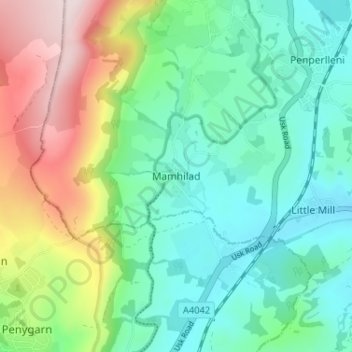
Name: Mamhilad topographic map, elevation, terrain.

Location: Mamhilad, Monmouthshire, Wales, NP4 0JF, United Kingdom (51.70539 -3.02721 51.74539 -2.98721)

Average elevation: 577 ft

Minimum elevation: 187 ft

Maximum elevation: 1,463 ft

Gear up for your next adventure:

🧣Hiking Neck Gaiter - Multi‑use neck protection for outdoor weather
🏔️Mountain Trail Maps - High‑detail maps for popular peaks
🎒Outdoor Daypacks - Lightweight backpacks designed for carrying maps and essential gear
🛡️Insect Repellent - Protection against bugs during outdoor activities
🥾Hiking Shoes - Durable and comfortable shoes for trail hiking

As an Amazon Associate, this site earns from qualifying purchases at no extra cost to you.