
Thank you for supporting this site ❤️
Make a donation
Make a donation
Gear up for your next adventure:
As an Amazon Associate, this site earns from qualifying purchases at no extra cost to you.
Vinobamba topographic map
Click on the map to display elevation.
Thank you for supporting this site ❤️
Make a donation
Make a donation
Gear up for your next adventure:
As an Amazon Associate, this site earns from qualifying purchases at no extra cost to you.
About this map
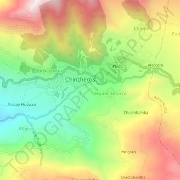
Name: Vinobamba topographic map, elevation, terrain.
Location: Vinobamba, Huancamarca, Chincheros, Apurímac, Perú (-13.54044 -73.74042 -13.50044 -73.70042)
Average elevation: 9,905 ft
Minimum elevation: 8,192 ft
Maximum elevation: 11,890 ft
Thank you for supporting this site ❤️
Make a donation
Make a donation
Gear up for your next adventure:
As an Amazon Associate, this site earns from qualifying purchases at no extra cost to you.