
Cubbington topographic map
Click on the map to display elevation.
About this map
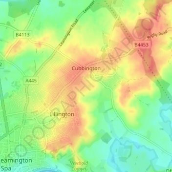
Name: Cubbington topographic map, elevation, terrain.
Location: Cubbington, Warwick, Warwickshire, England, United Kingdom (52.28955 -1.52830 52.32754 -1.47256)
Average elevation: 253 ft
Minimum elevation: 167 ft
Maximum elevation: 341 ft
Other topographic maps
Click on a map to view its topography, its elevation and its terrain.
Rowington Green
United Kingdom > England > Warwickshire > Warwick > Rowington
Average elevation: 374 ft
Hampton on the Hill
United Kingdom > England > Warwickshire > Warwick > Hampton on the Hill
Average elevation: 246 ft
Hill Wootton
United Kingdom > England > Warwickshire > Warwick > Leek Wootton
Average elevation: 226 ft