Geolocate

Catech topographic map

Click on the map to display elevation.

About this map

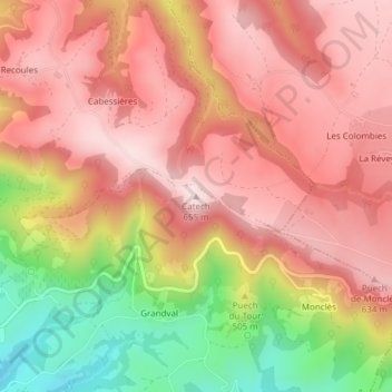
Name: Catech topographic map, elevation, terrain.

Location: Catech, Conques-en-Rouergue, Rodez, Aveyron, Occitanie, France métropolitaine, 12320, France (44.55853 2.44105 44.55863 2.44115)

Average elevation: 1,706 ft

Minimum elevation: 928 ft

Maximum elevation: 2,146 ft

Other topographic maps

Click on a map to view its topography, its elevation and its terrain.

Conques

France > Occitanie > Aveyron > Conques-en-Rouergue

Average elevation: 1,542 ft

Noailhac

France > Occitanie > Aveyron > Conques-en-Rouergue

Average elevation: 1,427 ft

Conques

France > Occitanie > Aveyron > Conques-en-Rouergue

Average elevation: 1,542 ft

Conques

France > Occitanie > Aveyron > Conques-en-Rouergue

Average elevation: 1,542 ft

Gear up for your next adventure:

🌲Outdoor Survival Books - Best books on survival skills
🏔️Mountain Trail Maps - High‑detail maps for popular peaks
📖Nature Tracking Books - Learn to track wildlife and terrain
🧣Merino Neck Gaiters - Multi-functional headwear for wind and sun protection
🛶Inflatable Kayak - Portable kayak for rivers, lakes, and expeditions

As an Amazon Associate, this site earns from qualifying purchases at no extra cost to you.