
Make a donation
Gear up for your next adventure:
As an Amazon Associate, this site earns from qualifying purchases at no extra cost to you.
Rio Grande topographic map
Click on the map to display elevation.
Make a donation
Gear up for your next adventure:
As an Amazon Associate, this site earns from qualifying purchases at no extra cost to you.
About this map
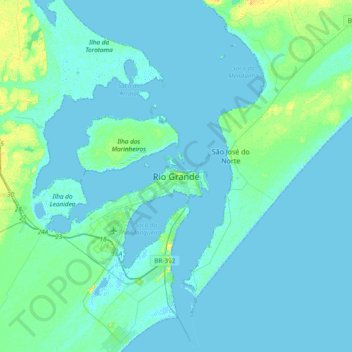
Name: Rio Grande topographic map, elevation, terrain.
Average elevation: 10 ft
Minimum elevation: -10 ft
Maximum elevation: 69 ft
Make a donation
Gear up for your next adventure:
As an Amazon Associate, this site earns from qualifying purchases at no extra cost to you.
Other topographic maps
Click on a map to view its topography, its elevation and its terrain.
Canal São Gonçalo
Brasil > Rio Grande do Sul > Aglomeração Urbana do Sul > Rio Grande
Average elevation: 30 ft
Ilha da Torotama
Brasil > Rio Grande do Sul > Aglomeração Urbana do Sul > Rio Grande
Average elevation: 3 ft
Canal São Gonçalo
Brasil > Rio Grande do Sul > Aglomeração Urbana do Sul > Rio Grande
Average elevation: 7 ft