Geolocate

Hampton topographic map

Click on the map to display elevation.

About this map

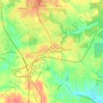
Name: Hampton topographic map, elevation, terrain.

Location: Hampton, Henry County, Georgia, United States (33.35249 -84.35409 33.40314 -84.24989)

Average elevation: 850 ft

Minimum elevation: 705 ft

Maximum elevation: 994 ft

Henry County trails, hiking, mountain biking, running and outdoor activities

Other topographic maps

Click on a map to view its topography, its elevation and its terrain.

Peeksville

United States > Georgia > Henry County

Average elevation: 646 ft

Fortson

United States > Georgia > Henry County > Hampton

Average elevation: 850 ft

Bowden

United States > Georgia > Henry County

Average elevation: 830 ft

Union

United States > Georgia > Henry County

Average elevation: 705 ft

Ola

United States > Georgia > Henry County

Average elevation: 755 ft

Gear up for your next adventure:

🪶Paracord Bracelet - Survival bracelet with built‑in tools
📦Gear Storage Bags - Organize and protect outdoor equipment
🪶Wildlife Field Guides - Learn animal tracking and species ID
🔦Compact Flashlight - Reliable flashlight for emergencies
🎁Geography Themed Gifts - Unique gift ideas for map lovers and geography enthusiasts

As an Amazon Associate, this site earns from qualifying purchases at no extra cost to you.