Geolocate

Embu topographic map

Click on the map to display elevation.

About this map

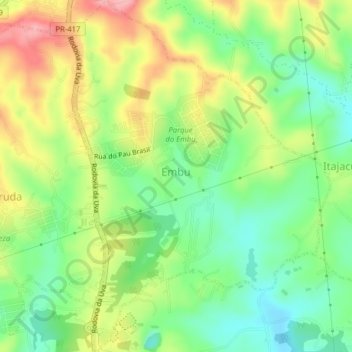
Name: Embu topographic map, elevation, terrain.

Location: Embu, Colombo, Região Geográfica Imediata de Curitiba, Região Metropolitana de Curitiba, Região Geográfica Intermediária de Curitiba, Paraná, Região Sul, Brasil (-25.32960 -49.22388 -25.29396 -49.19459)

Average elevation: 3,215 ft

Minimum elevation: 3,025 ft

Maximum elevation: 3,474 ft

Other topographic maps

Click on a map to view its topography, its elevation and its terrain.

Gear up for your next adventure:

🧦Hiking Socks - Comfortable socks to prevent blisters on long hikes
🌄Hiking Binoculars - Compact binoculars for scenic views and trail spotting
🏫Relief Map Kits - Hands-on tools for teaching landforms and elevation
Camping Coffee Makers - Enjoy premium coffee at the summit or campsite
🪶Fire Starter Kit - Reliable fire starter for survival and camping

As an Amazon Associate, this site earns from qualifying purchases at no extra cost to you.