
Make a donation
Gear up for your next adventure:
As an Amazon Associate, this site earns from qualifying purchases at no extra cost to you.
Morristown topographic map
Click on the map to display elevation.
Make a donation
Gear up for your next adventure:
As an Amazon Associate, this site earns from qualifying purchases at no extra cost to you.
Morristown
Morristown falls in the humid subtropical climate zone (Köppen climate classification Cfa), although it is not quite as hot as areas to the south and west of Tennessee due to the higher elevations. Summers are hot and humid, with July highs averaging 85 °F (29 °C), lows averaging 66 °F (19 °C), and an average of eight days per year with temperatures above 90 °F (32 °C). Winters are generally cool, with occasional small amounts of snow. January averages a high of around 45 °F (7 °C) and a low of around 28 °F (−2 °C), although low temperatures in the single digits and teens are not uncommon. The record high for Morristown, since 1994, is 103 °F (39 °C), while the record low is −2 °F (−19 °C). Annual precipitation averages around 44.3 in (1,125 mm), and average winter snowfall is 11.7 inches (30 cm). The average monthly relative humidity is around 70 percent.
Make a donation
Gear up for your next adventure:
As an Amazon Associate, this site earns from qualifying purchases at no extra cost to you.
About this map
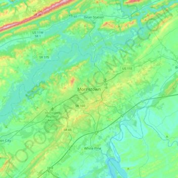
Name: Morristown topographic map, elevation, terrain.
Location: Morristown, Hamblen County, Tennessee, 37814, United States (36.05398 -83.45489 36.37398 -83.13489)
Average elevation: 1,240 ft
Minimum elevation: 948 ft
Maximum elevation: 2,444 ft
Hamblen County trails, hiking, mountain biking, running and outdoor activities
Make a donation
Gear up for your next adventure:
As an Amazon Associate, this site earns from qualifying purchases at no extra cost to you.