
Make a donation
Gear up for your next adventure:
As an Amazon Associate, this site earns from qualifying purchases at no extra cost to you.
Herstelle topographic map
Click on the map to display elevation.
Make a donation
Gear up for your next adventure:
As an Amazon Associate, this site earns from qualifying purchases at no extra cost to you.
Herstelle
Aus der (sächsisch?-) fränkischen Wallburg entstand eine spätmittelalterliche Burg der Paderborner Bischöfe, aus der geplanten Bischofskirche im Schutze der Burg ging eine Ortskirche mit Pfarrhaus hervor, woraus mittlerweile eine imposante burgartige Klosteranlage auf der Anhöhe neben der Burg entstand. Die Benediktinerinnen dort führen auch geistig das frühmittelalterliche Erbe fort. Die Ortskirche wurde 1711 in den Ort ins Wesertal verlegt.
Make a donation
Gear up for your next adventure:
As an Amazon Associate, this site earns from qualifying purchases at no extra cost to you.
About this map
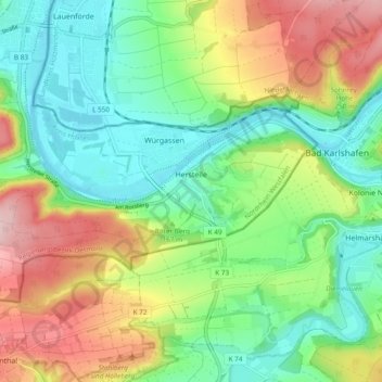
Name: Herstelle topographic map, elevation, terrain.
Average elevation: 577 ft
Minimum elevation: 295 ft
Maximum elevation: 1,060 ft
Make a donation
Gear up for your next adventure:
As an Amazon Associate, this site earns from qualifying purchases at no extra cost to you.
Other topographic maps
Click on a map to view its topography, its elevation and its terrain.
Bustollen
Deutschland > Nordrhein-Westfalen > Kreis Höxter > Beverungen > Dalhausen
Average elevation: 869 ft