
Thank you for supporting this site ❤️
Make a donation
Make a donation
Gear up for your next adventure:
As an Amazon Associate, this site earns from qualifying purchases at no extra cost to you.
Fluorn-Winzeln topographic map
Click on the map to display elevation.
Thank you for supporting this site ❤️
Make a donation
Make a donation
Gear up for your next adventure:
As an Amazon Associate, this site earns from qualifying purchases at no extra cost to you.
Fluorn-Winzeln
Fluorn-Winzeln liegt am Ostrand des Schwarzwalds über dem Neckartal, rund sechs Kilometer westlich von Oberndorf am Neckar auf einer Höhe von 649 m ü. NN.
Thank you for supporting this site ❤️
Make a donation
Make a donation
Gear up for your next adventure:
As an Amazon Associate, this site earns from qualifying purchases at no extra cost to you.
About this map
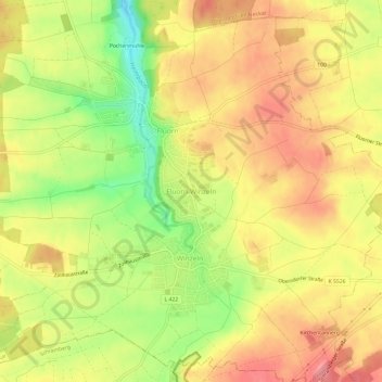
Name: Fluorn-Winzeln topographic map, elevation, terrain.
Average elevation: 2,178 ft
Minimum elevation: 1,995 ft
Maximum elevation: 2,303 ft
Thank you for supporting this site ❤️
Make a donation
Make a donation
Gear up for your next adventure:
As an Amazon Associate, this site earns from qualifying purchases at no extra cost to you.