
Make a donation
Gear up for your next adventure:
As an Amazon Associate, this site earns from qualifying purchases at no extra cost to you.
Waidring topographic map
Click on the map to display elevation.
Make a donation
Gear up for your next adventure:
As an Amazon Associate, this site earns from qualifying purchases at no extra cost to you.
About this map
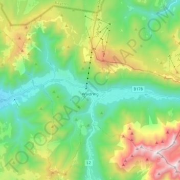
Name: Waidring topographic map, elevation, terrain.
Location: Waidring, Bezirk Kitzbühel, Tyrol, 6384, Autriche (47.53653 12.50838 47.63647 12.66662)
Average elevation: 4,058 ft
Minimum elevation: 2,162 ft
Maximum elevation: 8,110 ft
Make a donation
Gear up for your next adventure:
As an Amazon Associate, this site earns from qualifying purchases at no extra cost to you.
Other topographic maps
Click on a map to view its topography, its elevation and its terrain.
Steinplatte
Autriche > Tyrol > Bezirk Kitzbühel > Waidring
Le Steinplatte ou Kammerköhrplatte est un sommet des Alpes, à 1 869 m d'altitude, dans les Alpes de Chiemgau, en Autriche (limite entre le land du Tyrol et le land de Salzbourg).
Average elevation: 4,698 ft