Geolocate

Watsonville topographic map

Click on the map to display elevation.

About this map

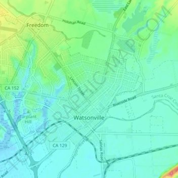
Name: Watsonville topographic map, elevation, terrain.

Location: Watsonville, Santa Cruz County, California, USA (36.89450 -121.80164 36.94169 -121.73233)

Average elevation: 56 ft

Minimum elevation: -10 ft

Maximum elevation: 266 ft

Gear up for your next adventure:

🎒Outdoor Daypacks - Lightweight backpacks designed for carrying maps and essential gear
🦺Reflective Outdoor Gear - Safety gear for low‑light conditions
🧥Men's Rain Shells - Premium waterproof and breathable jackets for mountain weather
🏥Hiking First Aid Kits - Comprehensive medical kits for remote trail injuries
🎁Geography Themed Gifts - Unique gift ideas for map lovers and geography enthusiasts

As an Amazon Associate, this site earns from qualifying purchases at no extra cost to you.