
Make a donation
Gear up for your next adventure:
As an Amazon Associate, this site earns from qualifying purchases at no extra cost to you.
Westport topographic map
Click on the map to display elevation.
Make a donation
Gear up for your next adventure:
As an Amazon Associate, this site earns from qualifying purchases at no extra cost to you.
About this map
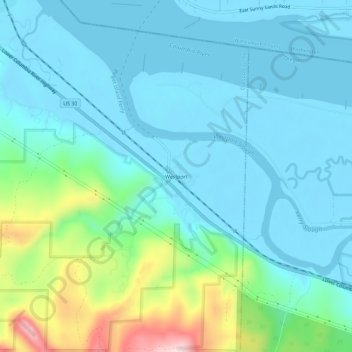
Name: Westport topographic map, elevation, terrain.
Location: Westport, Clatsop County, Oregon, United States (46.11261 -123.39485 46.15261 -123.35485)
Average elevation: 200 ft
Minimum elevation: -7 ft
Maximum elevation: 1,040 ft
Clatsop County trails, hiking, mountain biking, running and outdoor activities
Make a donation
Gear up for your next adventure:
As an Amazon Associate, this site earns from qualifying purchases at no extra cost to you.
Other topographic maps
Click on a map to view its topography, its elevation and its terrain.
Cannon Beach
United States > Oregon > Clatsop County
Cannon Beach is recognized by the well-known landmark Haystack Rock, located southwest of downtown Cannon Beach. This sea stack has an elevation of 235 feet (72 m) and is often accessible at low tide, especially in the summertime. There is a small cave system that penetrates its igneous rock that can be seen…
Average elevation: 138 ft
Make a donation
Gear up for your next adventure:
As an Amazon Associate, this site earns from qualifying purchases at no extra cost to you.