
Make a donation
Gear up for your next adventure:
As an Amazon Associate, this site earns from qualifying purchases at no extra cost to you.
Hüchel topographic map
Click on the map to display elevation.
Make a donation
Gear up for your next adventure:
As an Amazon Associate, this site earns from qualifying purchases at no extra cost to you.
Hüchel
Der Ort liegt in einer Höhe von 200 Metern über N.N. auf den Hängen des Westerwaldes, aber noch im Naturpark Bergisches Land. Im Osten liegt Uckerath, im Süden Büllesbach, im Südwesten Zumhof, im Westen Derenbach im Nordwesten Lichtenberg.
Make a donation
Gear up for your next adventure:
As an Amazon Associate, this site earns from qualifying purchases at no extra cost to you.
About this map
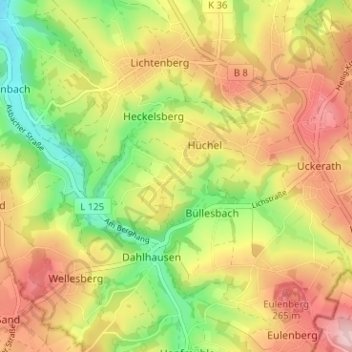
Name: Hüchel topographic map, elevation, terrain.
Average elevation: 604 ft
Minimum elevation: 289 ft
Maximum elevation: 902 ft
Make a donation
Gear up for your next adventure:
As an Amazon Associate, this site earns from qualifying purchases at no extra cost to you.