
Cassandra topographic map
Click on the map to display elevation.
About this map
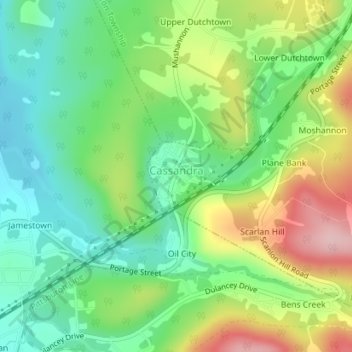
Name: Cassandra topographic map, elevation, terrain.
Average elevation: 1,886 ft
Minimum elevation: 1,647 ft
Maximum elevation: 2,287 ft
Cambria County trails, hiking, mountain biking, running and outdoor activities
Other topographic maps
Click on a map to view its topography, its elevation and its terrain.
Parkhill
United States > Pennsylvania > Cambria County > East Taylor Township
Average elevation: 1,604 ft
Mineral Point
United States > Pennsylvania > Cambria County > East Taylor Township
Average elevation: 1,729 ft
Spangler Reservoir
United States > Pennsylvania > Cambria County > Barr Township
Average elevation: 1,923 ft
Twin Rocks
United States > Pennsylvania > Cambria County > Blacklick Township
Average elevation: 1,844 ft
Fallentimber
United States > Pennsylvania > Cambria County > Reade Township
Average elevation: 1,568 ft
Elmora
United States > Pennsylvania > Cambria County > West Carroll Township
Average elevation: 1,913 ft
Saint Michael
United States > Pennsylvania > Cambria County > Adams Township
Average elevation: 1,775 ft
Beaverdale
United States > Pennsylvania > Cambria County > Summerhill Township
Average elevation: 2,178 ft
Gallitzin Tunnelhill Park
United States > Pennsylvania > Cambria County > Gallitzin
Average elevation: 2,238 ft
Bakersville
United States > Pennsylvania > Cambria County > Cambria Township
Average elevation: 2,175 ft