
Thank you for supporting this site ❤️
Make a donation
Make a donation
Gear up for your next adventure:
As an Amazon Associate, this site earns from qualifying purchases at no extra cost to you.
Mogalakwena topographic map
Click on the map to display elevation.
Thank you for supporting this site ❤️
Make a donation
Make a donation
Gear up for your next adventure:
As an Amazon Associate, this site earns from qualifying purchases at no extra cost to you.
About this map
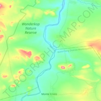
Name: Mogalakwena topographic map, elevation, terrain.
Location: Mogalakwena, Limpopo, RSA (-23.40473 28.63583 -23.27025 28.69690)
Average elevation: 2,907 ft
Minimum elevation: 2,697 ft
Maximum elevation: 3,438 ft
Thank you for supporting this site ❤️
Make a donation
Make a donation
Gear up for your next adventure:
As an Amazon Associate, this site earns from qualifying purchases at no extra cost to you.